Vector Maps UK

Layered Vector Maps
of all cities and regions
of England and the UK

Detailed Vector Maps of any City or Region in the UK

We will deliver you the best digital vector map for your needs:

  • At 123VectorMaps.com you will find digital vector maps of all cities, counties and regions of the United Kingdom
  • All of our UK maps come in popular file formats so you can choose the best option: Adobe Illustrator (.ai), JPEG (.jpg) or EPS format
  • Define the area of your choice and determine the zoom level
  • Choose from four different map styles to suit your project
  • Download your map within 24 hours after ordering
  • Affordably priced: map prices start at € 100,- (royalty-free use)

High-quality Vector Maps for All Projects

Maps for Graphic Design and Business Professionals:

  • With over 10 years of experience, 123VectorMaps.com is the European leader in 
high-quality vector mapping services
  • Our maps are used by business professionals worldwide
  • Our easy-to-use editable vector maps can give your brochures, graphic design materials and other publications both credibility and a professional edge
  • If you can’t find the map you need, allow us to create a custom map for you

Royalty-Free and Versatile Usage

The best layered, editable vector maps, easily ordered:

  • All of our maps are royalty-free; this allows you to use the map over and over for an unlimited number of projects
  • All maps are available online for immediate purchase, using our secure e-commerce system
  • All maps are delivered in completely editable formats and structured by layers of information

EPS vector map JPG vector map

Select Your Vector Map of the UK Contact Us for Advice

Detailed Example of a Vector Map of England/UK

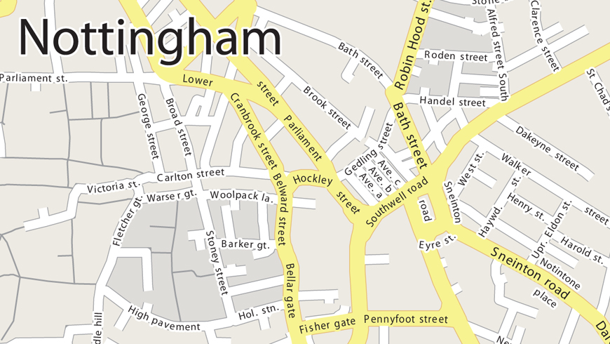
Example Vector Map of Nottingham

Detailed example of a vector map of Nottingham.

Vector maps of the United Kingdom

The United Kingdom, officially known as “The United Kingdom of Great Britain and Northern Ireland”, is a sovereign state in Western Europe and includes four countries: England, Wales, Northern Ireland and Scotland. The country is surrounded by the Atlantic Ocean, North Sea, English Channel and the Irish Sea. Northern Ireland is the only region of the UK that shares a land border with another country: the Republic of Ireland.

Order Vector Map of United Kingdom

The United Kingdom, which is a monarchy, is a developed economy. It is the 7th largest economy of the world in terms of nominal GDP and the 8th largest by Purchasing Power Parity (PPP). UK is a permanent member of the United Nations and a member of the European Union, the G7, the G8, the G20, NATO, the Council of Europe, Commonwealth of Nations, the Organization for Economic Co-operation and Development (OECD) and the World Trade Organization.

Vector Maps of Regions of the UK

Vector Map of England

England, of which London is the capital city, is the largest and most populous of all countries in the United Kingdom. England is divided into three regions: Southern England, South East England and West Country.

Order Vector Map of England

Vector Map of Scotland

Scotland is divided into: Borders, South West, North East Scotland, Central Belt, North East Scotland, Hebrides, Highlands, Orkney Islands and Shetland Islands. Edinburgh is the capital city of Scotland while Glasgow is the largest city in the country.

Order Vector Map of Scotland

Vector Map of Wales

Wales lies in the western peninsula of the Island of Great Britain. Wales is bound by England to the east and the Irish Sea to the west. The country is divided into three regions: North Wales, Mid Wales, and South Wales. Cardiff is the capital and the largest city of Wales.

Order Vector Map of Wales

Vector Map of Northern Ireland

Northern Ireland is one of the constituent countries of the United Kingdom. There are six counties that form Northern Ireland, namely: County Antrim, County Armagh, County Londonderry, County Down, County Fermanagh, and County Tyrone. Belfast is the capital and the largest city of Northern Ireland.

Order Vector Map of Northern Ireland

Vector Maps of Major Cities of the UK

The major cities of the UK are:

Vector Map of London

London is the capital and the largest city of both the United Kingdom and England. It is located on the banks of River Thames. The city has 32 boroughs. London is one of the most popular tourist destinations in the world.

Order Vector Map of London

Vector Map of Manchester

One of the largest urban areas of the UK is Manchester. It is a metropolitan borough in the Greater Manchester, England. The city is located in the North West region of England.

Order Vector Map of Manchester

Vector Map of Liverpool

Liverpool is located in North West England. It is a metropolitan borough in Merseyside, England. The city has several heritage sites.

Order Vector Map of Liverpool

Vector Map of Birmingham

One of the most populous British cities is Birmingham. It lies in the West Midlands of England. Inhabitants of Birmingham are known as 'Brummies’.

Order Vector Map of Birmingham

Vector Map of Bristol

The 6th most populous city of England, Bristol, is also a unitary authority area and ceremonial county in South West England. People from Bristol are called ‘Bristolians’.

Order Vector Map of Bristol

Vector Map of Leeds

Leeds can be considered as a Gamma World City. The city and metropolitan borough is situated in West Yorkshire, England. The University of Leeds attracts many international students.

Order Vector Map of Leeds

Vector Map of Belfast

Belfast is the capital and the largest city of Northern Ireland and also the 14th largest city in the United Kingdom. Belfast is popular for being a center for the Irish linen industry. Hence its nickname "Linenopolis".

Order Vector Map of Belfast

Vector Map of Glasgow

The largest city in the Scotland, Glasgow, is the 3rd most populous city in the United Kingdom. Glasgow is gearing up to host the 2014 Commonwealth Games.

Order Vector Map of Glasgow

Vector Map of Edinburgh

The capital city of Scotland, Edinburgh, is the second largest city in Scotland and the 7th most populous city in UK. The city is famous for hosting the “Edinburgh Festival”.

Order Vector Map of Edinburgh

Vector Map of Aberdeen

Aberdeen, a quintessentially Scottish city, is the 3rd most populous city in the country and 29th of the most populous in UK.

Order Vector Map of Aberdeen

Vector Map of Inverness

Inverness, a beautiful city in the Scottish Highlands, is situated at the mouth of the River Ness.

Order Vector Map of Inverness

Vector Map of Perth

Perth is located on the banks of the River Tay in the central region of Scotland.

Order Vector Map of Perth

Vector Map of Dundee

The fourth largest city in Scotland, Dundee, is the 38th most populous city in UK. Dundee is also referred to as the City of Discovery.

Order Vector Map of Dundee

Vector Map of Cardiff

Cardiff is the capital and the largest city of Wales. It is the 10th largest city in the United Kingdom. Cardiff is an important tourist center and the most popular visitor destination in Wales.

Order Vector Map of Cardiff

Select Your Vector Map of the UK Contact Us for Advice